There are plenty of opportunities along the peninsula for getting “lost” and off the beaten path. Here are a few of our favorite Baja destinations for when we need to get away.
 Parque Nacional Constitución de 1857

Location: Sierra de Juárez, BC
Why We Love It: Nestled into the mountains and pine trees, this national park is in the highest part of the Sierra de Juárez mountain range and covers over 12,000 acres. It’s a protected refuge for wildlife such as bobcats, foxes, coyotes, eagles, and hawks. The high elevation brings snows in the winter, but provides beautifully fresh weather during the summer.
What To Do: Laguna Hanson (officially Laguna Juárez), a beautiful high meadow lake, is one of the main attractions here. While the shallow lake has mostly dried up in recent years, it does have some water certain times of the year depending on recent rain fall. Regardless of water levels, it’s a beautiful and serene spot for camping and exploring and the marshlands attract a variety of birds making Laguna Hanson a great place to camp, hike, and bird-watch. Large granite boulders and pine trees offer scenery very different from the rest of the peninsula.
Where To Stay: Many people tent camp as there are nine camping areas within the park. There are also a few rustic cabins available starting at US$28.
How to Visit: The park can be accessed from the north on Mexico 2 at Km. 71, or from the south on Mexico 3 (Ensenada-San Felipe) at Km. 53. There are administration buildings at both entrances where visitors will need to register and pay the park fee. Overnight camping is included in the park fee.
DBTC Insider Tip: Parque Nacional Constitución de 1857 is one of only two national parks in the state of Baja California (norte)—the other is Sierra de San Pedro Mártir.
Vizcaíno Peninsula
Location: Southwest of Guerrero Negro, BCS
Why We Love It: This remote Pacific region is a part of the Vizcaíno biosphere reserve, the largest wildlife refuge in Latin America. At 9,625 square miles, the biosphere reserve encompasses Guerrero Negro down to Santa Rosalía along the Sea of Cortez and down to Laguna San Ignacio on the Pacific Coast. The area protects the impressive flora, fauna, and cultural sites. There are various destinations along the Vizcaíno Peninsula including Bahía Tortugas, Bahía Asunción, Punta Abreojos, and La Bocana.
What To Do: Travelers come to the area for fishing, surfing, windsurfing, or just relaxing. In Bahía Asunción, don’t miss the small natural bufadora (blowhole) along the beach where the water meets the rocks to create a small geyser.
Where To Stay: In Bahía Asunción most visitors stay at La Bufadora Inn where there are six rooms and casitas available to rent. Also in Bahía Asunción is Campo Sirena, a full-service campground on the beach with tent camping and power and water hookups for RVs. In La Bocana, Baja Bocana B&B (tel. 011-52-615-156-0056) is a large house with seven rooms comfortable for a relaxing stay. Or south of Punta Abreojos, Campo Rene offers simple cabins or for camping for a stay on Estero de Coyote.
How to Visit: To reach Bahía Asunción, turn off of Mexico 1 at Vizcaíno at Km. 143.5 and drive west on the paved road until the highway junction at Km. 75. Turn left here and head south for another 39 kilometers to reach Bahía Asunción. To get to Abreojos, turn off of Mexico 1 just north of kilometer 97. Follow the paved road 88 kilometers to the coast.
DBTC Insider Tip: Fall is the most popular time for travel to this area so make your reservations in advance.
 Sierra de San Francisco
Location: Southeast of Guerrero Negro, BCS
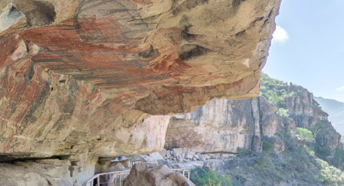
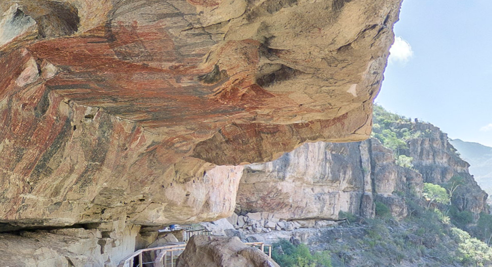
Why We Love It: One of the most impressive and unique experiences in Baja is the cave paintings of the Sierra de San Francisco. Just recently reopened for visitors after being closed for a year due to COVID, this UNESCO World Heritage Site encompasses some of the best-preserved and most impressive Great Mural sites in the world. Four hundred rock art sites have been recorded in the region, and most remain intact and in good condition, attributable to the dry climate and remote location. Visitors will find rock shelters and huge panels decorated with depictions of human figures as well as marine and land wildlife, painted in red, black, white, and yellow.
What To Do: It’s necessary to dedicate 3-4 days to fully visit the cave paintings as the best rock art is only reachable by hiking and riding a pack animal while camping in the sierras. The most-photographed and well-known paintings of the Sierra de San Fransicso (and of the entire peninsula) are those of La Pintada in San Pablo Canyon.
Where To Stay: The Buenaventura Hostel (tel. 011-52-615-156-4747, buenaventurahostal@gmail.com) is the only option for accommodations in the small town of San Francisco, and most visitors spend the night here before venturing out on their multi-day treks early the next morning. For those who just want a small sample of the cave paintings, it’s possible to stay in San Ignacio and do a day trip to visit the El Ratón site or Palmarito outside of Santa Marta.
How to Visit: There is a turnoff for San Francisco off of Mexico 1 at kilometer 117.5. It takes about 1.5 hours to reach San Francisco from the highway. All visitors to the rock art must be registered with INAH, Mexico’s National Institute of Anthropology and History, and have a guide. You can book a guide directly through the Buenaventura Hostel (tel. 011-52-615-156-4747, buenaventurahostal@gmail.com) in Sierra de San Francisco. It’s too hot to go down into the canyons from June-September. April, May, and October are generally considered the best months to visit the cave paintings.
DBTC Insider Tip: If you want to explore Baja’s cave paintings, but aren’t quite ready to commit to a trip in person, check out the Senda Rupestre website that gives you a 360-degree virtual experience of some of Baja’s best cave painting sites.
 Comondú

Location: West of Loreto, BCS
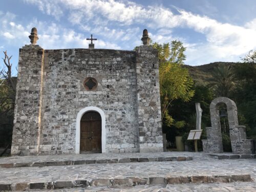
Why We Love It: The remote villages of San Jose de Comondú and San Miguel de Comondú are known collectively as Comondú. Located in a fertile ravine three kilometers apart, both offer travelers the feeling of stepping back in time. Each has a small plaza surrounded by colonial buildings (although many of the buildings have fallen into disrepair) and basic services. The region is rich with agriculture—fruits, vegetables, sugarcane, dates, figs, olive trees, and vineyards first planted by the missionaries. Because of these resources, the region for a long time was very prosperous and almost self-sufficient. Today, these two oasis villages are sleepy and not visited by many tourists.
What To Do: The area is home to petroglyphs, cave paintings, rugged peaks, natural springs and pools, prism rock formations, and desert scenery. It’s also home to the fifth mission built in California, Misión San José de Comondú, founded by Jesuit Padre Julián de Mayorga in 1716. The location is now known as San Miguel de Comondú. The remains of the original mission location are between the ranches of San Juan and La Presa. A side chapel to the main church was preserved and can be seen today in San José de Comondú.
Where To Stay: Located in San Miguel de Comondú, Hacienda Don Mario is the only option for accommodations in the Comondú, and is a nice new hotel offering six rooms with air-conditioning and kitchenettes. They can help arrange for tours and sightseeing around the area. You’ll need to make reservations in advance and at the same time arrange with them to have your meals at the hotel as there are no restaurant options around.
How to Visit: The easiest way to get to Comondú is to take a paved road north from Ciudad Insurgentes (the branch of Mexico 1 that does not go to Loreto) and take the Comondú turnoff in Ejido Francisco Villa. It’s a beautiful drive through lush canyons. Another scenic route is from a turnoff of Mexico 1 at kilometer 60, south of Bahía Concepción. A third option, currently in rough condition, is accessed from the road out to San Javier from Mexico 1.
DBTC Insider Tip: If you visit Comondú, it’s worth it to visit nearby San Isidro and La Purísima. There’s a dirt road connecting the two areas that requires 4-wheel drive, but it can sometimes be in bad shape so inquire locally about current road conditions. Otherwise, you can head back out to the paved highway to drive to La Purísima from Comondú.
 Bahía San Juanico
Location: BCS
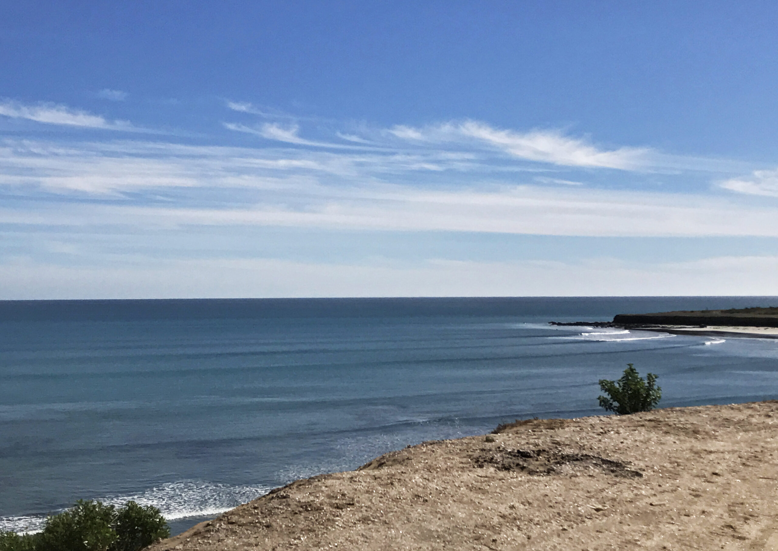
Why We Love It: Bahía San Juanico, also called Scorpion Bay, is arguably the most popular spot for surfing on the entire Baja peninsula. This small, remote fishing village on the Pacific has become a classic Baja surfing spot. While the roads out to Bahía San Juanico can be treacherous, for serious surfers it’s worth the hassle to get to the series of right point breaks with seemingly endless waves.
What To Do: The main attraction here is definitely the surfing. In total, there are eight right point breaks in the area, although the first four are the most famous. The points break on south swells, which occur between March and November. On big days, a ride can last over a minute. This isn’t a commercialized tourist surfing spot—there are no surfing lessons for beginners or board rentals on the beach. This is a destination for serious surfers. It’s still a good spot for beginners on small days, but larger days are best reserved for the experienced.
Where To Stay: The hub of social life for surfers and visitors to San Juanico is the Scorpion Bay Cantina and Campground. Most visitors tent camp here or there are sleeping palapas or an apartment or suite available to rent as well. Guests gather at The Cantina, a large palapa serving breakfast, lunch, and dinner daily. For more high-end accommodations, Scorpion Bay Hotel (DBTC members receive a 15% discount) has a number of casitas and bunkhouses. Breakfast is included with your stay, and lunch and dinner are available upon request.
How to Visit: There are three ways to drive into San Juanico and it’s a topic of discussion for all who visit. The South Road from Ciudad Insurgentes is now completely paved. This is the easiest, but longest route and optimal if you’re towing anything or do not have four-wheel drive. The East Road is a rough dirt road that is not used often and can be especially challenging if there have been recent hurricanes or rainstorms. If the road is passable, you will need to have four-wheel drive and spare tires with you. The North Road is currently the preferred off-road option. The route is 170 kilometers from San Ignacio.
DBTC Insider Tip: While most of Baja Sur shuts down for the hot days of late summer, this is peak season for surfing. There are very few services here (no ATMS—make sure to bring pesos with you as you will need to pay cash nearly everywhere in San Juanico) and no reliable cell phone service. Check out Carla King’s article on exploring San Juanico for more tips.