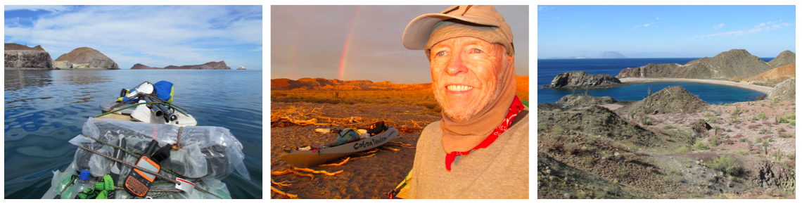
By Graham Mackintosh
Isla Ángel de la Guarda is about ten miles offshore from Bahía de los Ángeles. It is 42 miles long, about eight miles wide at its widest, and approximately 100 miles in circumference. There are no permanent settlements on the island.
My goal late October/early November this year was to kayak all the way around on my ultra-stable Cobra Tandem sit-on-top. If lucky with the winds I guessed I could do it in about two weeks. But I had food and everything I needed for at least a month.
I had water for about a week, after that I’d need to pick up some or desalinate sea water. I had two hand-pump desalinators, and as backup I had kettle and tubes to rig up a basic still.
I also carried a SPOT 2-way satellite messenger with which I could transmit my status and receive brief messages, and if necessary activate it as an SOS device.
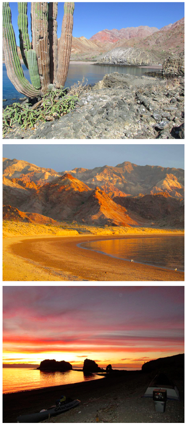
I hired a panga to take me across the Canal de las Ballenas and drop me in the beautiful, protected cove of Este Ton, about two-thirds of the way down the west coast of the island.
Once there, I had to wait three days for the winds to drop. On Halloween I found myself staring at a black cat! Feral cats are thriving after they were left behind from an island scallop camp in the 1970s. How they get through the long, hot, dry summers with temperatures in excess of 100 F. is a mystery.
At first light on Nov. 2, I set off south. The new moon extreme tides around the island would be draining south, and paddling against them was not possible – at least not for me on my heavily stacked sit-on-top kayak.
The long range weather forecast suggested I’d have a 3-4 day calm spell to work my way around the southern tip of the island and up the east coast.
When possible, I was paddling before dawn. The clear night sky and bioluminescence around and beneath the kayak was fantastic and hypnotic. Overall, I intended keeping as close to shore as I could, ready to land within minutes if conditions deteriorated. But, at night I had to move out to minimize the chance of colliding with a rock or reef.
After a night launch it was always a relief to see sunup. I was able to move back in and look out for potential landings. Even under cliffs there was usually a landing of some kind every few hundred yards.
There were several places I was eager to get beyond if the weather remained fair. A few miles up the east coast, waves and currents could be extreme passing over the shallows between Isla Estanque and Ángel de la Guarda.
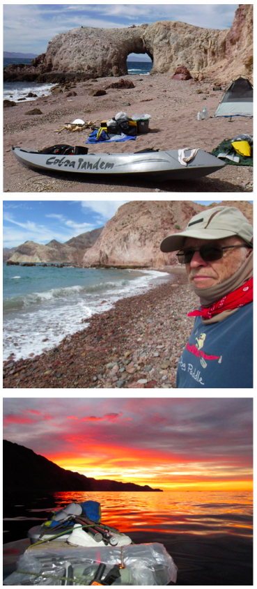
I had great weather to deal with it. I made camp on a steep, calm beach half a mile beyond Isla Estanque. Expecting another fine day, I again launched in the dark and headed towards the dramatic and colorful cliffs of Punta Rocosa.
Passing a series of low bluffs and cliffs I noted several osprey nests right on the ground. So much of the rugged island looks like anywhere on the peninsula with cardóns and other familiar cacti. But there are striking differences probably related to the widespread presence of feral cats and the absence of coyotes. I didn’t see a single vulture while I was out there.
I saw very few people around the island, mostly divers from the mainland. Dolphins, sea lions, and sea turtles were my constant companions. I must have seen 100 turtles – usually they’d wake to my presence and gently slip beneath the water as I approached.
Adrenalin kept me tirelessly paddling hour after hour. Punta Rocosa got closer. The day remained calm. I decided to try and pass it. It was an awesome sight with numerous caves to explore and major fish boils inviting me to cast a line, but I wasn’t inclined to do so, getting beyond was all consuming.
Safely around, I looked for where to land. I chose a wonderfully protected and gently sloping beach with great views back and ahead. A stillness descended and with it visible clouds of no-see-ums. I quickly covered up with long pants and a jacket and smeared all exposed skin in repellent. Without repellent or netting it would have been very uncomfortable.
Before retiring to my no-see-um-proof tent, my flashlight beam caught a pair of glowing cat’s eyes at water’s edge. As I walked over I could see a gray cat crouched behind a rock. I took a couple of pictures before it took off.
Next up, around the generally low coast of Bahía Pulpito was another stark headland – Punta Pulpito.
At first the day was still and beautiful. While I stood with my kayak on a pebble beach, a school of jacks attacked a long line of bait fish all around me, driving thousands on to the beach, much to the delight of the gulls. Several of the larger fish collided with me as I stood in the shallows and I found bait fish in my kayak hours later.
The wind picked up, a headwind. As tiring as it was, I was determined to get close to Punta Pulpito and kept going. Late in the afternoon, I reached the cliffs. The cliffs weren’t as high or as extensive as those of Punta Rocosa. I went for it, and was delighted to be setting up camp beyond the point.
Hoping for another fine day, I launched by first light. I took it point by point heading north, grateful I wasn’t battling a headwind.
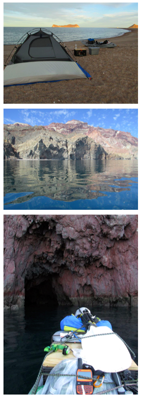
Seeing the island closely, quietly at a walking pace, the coast was intriguing and beautiful. Yellow bluffs and headlands gave way to more red rocks and cliffs. High mountains rose beyond. A series of protected beaches were covered with noisy sea lions.
I was able to get beyond them ’till a gorgeous narrow landing with cliffs and caves tempted me to stop. I needed water.
I made camp, got out one of my desalinators and returned to my kayak for nearly an hour to hand pump over a half-gallon of water.
The following day was delightful and calm. I could easily have reached Puerto Refugio, but I was so enamored with the lovely little bay I decided to enjoy a rest day, hike around, and make more drinking water.
Next day, I left before dawn hoping for more calm weather. Soon, though, a strong breeze was striking me in the face. What I could have done easily the day before became a hard, challenging paddle around gusting headlands and over surf-wracked reefs. I daren’t go too far out for fear I’d be swept offshore.
I carried on hoping conditions would improve. They didn’t… ’till I was deep in the extensive anchorage of Puerto Refugio at the north end of the island which, beautiful as it was, wasn’t north protected. I was dealing with white caps and a long rolling swell running into the rocks.
I made my way as far west as I could and found a tolerably sheltered landing on a sand beach. Late in the day, all thoughts of rest aside, I paddled out again for an hour to pump another half-gallon of drinking water.
I was ready at first light, determined to exit Refugio and return to the peninsula side, heading south with the prevailing wind behind me.
The sight of the morning sun on white Sail Rock was spectacular. For a couple of miles I was dealing with residual high seas and hoping they’d moderate. I checked out a couple of beautiful bays on the protected south side of a dramatic line of rocks. Landing was easy but the stony beaches were steep and there was nowhere comfortable to camp.
A little further south there was a near perfect spot in a bay just past a group of nearly connected islands. I chose a spot deep in the bay where there was no danger of encountering rocks at low tide. I was able to hand pump another half-gallon of water and admire a gorgeous sunset over the Baja peninsula.
I chose to get going early to take advantage of the receding tide. Awake at 1 AM, I was launched by 3 AM. The moon was almost full. I had its assistance for over an hour. When it set it was so dark I could see the faint glow of Bahía ahead and again enjoy the light show of phosphorescence from my paddle strokes and the movement of the kayak. For a further hour it was mesmerizing and unreal. As dawn approached I was hallucinating rocks and tsunami’s and was glad to make out the coast again.
By the time I pulled ashore for a break I’d already been paddling for three hours! My day was just beginning. The tide would soon turn and I wanted to keep going.
When the water came flowing back, it did so visibly and dramatically. Surrounded by flow lines, upwellings and eddies, I was approaching the narrowest point of the Canal de las Ballenas, separating Baja from the island. The full moon tide was surging against me.
My progress almost came to a halt but thanks to a moderate tailwind and using countercurrents close to shore I was able to carry on.
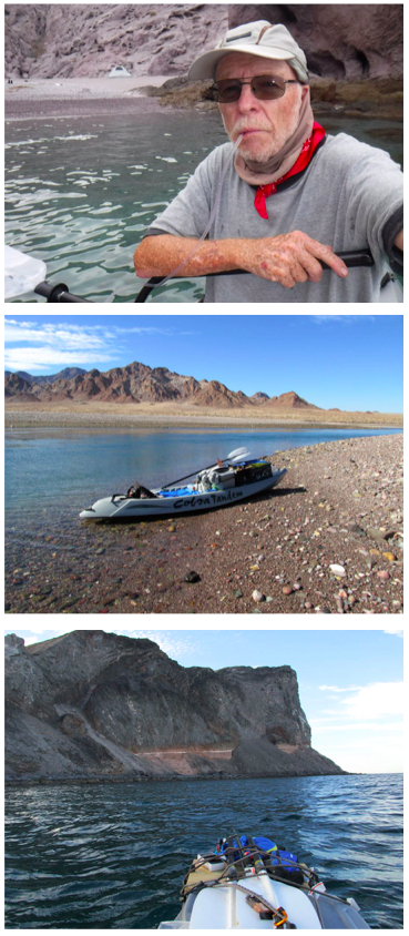
The cliffs of Punta Los Machos beckoned. I went for it reassured I’d soon have wind and tide at my back. The wind actually dropped to nothing and I paddled beneath the tall, dark headland noting that nearly all the landing spots were packed with sea lions.
The draining tide helped carry me around… and it even started to sprinkle.
I slowly worked my way around Humbug Bay to a sheltered inner bay, camping in the middle. The better protected north end was very rocky at low tide. And with the full moon approaching the tide would be very low early morning effectively trapping me.
After making another half-gallon of drinking water, and enjoying a rainbow, I planned on another night launch so I wouldn’t be dealing with rocks at low tide. I retired to my tent, set my alarm, and fell asleep listening to the gentle sounds of the sea.
Around midnight I was woken by the roar of surf. With high tide, waves were running up the beach threatening my tent. I had to move it and all my possessions. There was almost no wind. I was baffled. Where was the surf coming from? I switched off my alarm and slept till dawn.
The tide fell very low in the morning exposing rocks even in the middle of the bay. I had missed the night launch window. Strong winds were forecast. I expected to be staying where I was for days, an unprotected but beautiful spot with abundant drift wood.
As the tide rose again in the morning and the seas moderated, I gambled and launched. I’d have a safe landing if I could get back to Este Ton.
For an hour I had a head-on rising tide to deal with and the north wind was blowing a little more than I’d like. But at least it compensated for the tide. When the tide finally turned, I paddled rapidly past high cliffs looking at every landing spot… just in case.
I was delighted to be approaching Este Ton. As I pulled in, I saw a panga, and five friendly mainlanders sleeping on the beach. They were from Bahía Kino and were there night diving. They gave me a gallon of water and I gave them some cereal bars.
I paddled to another beach inside the bay and leisurely set up camp. Having a whole gallon of water meant I could enjoy a coffee or two. (Next morning, the divers left, and were kind enough to give me another gallon of water.)
That evening I used my SPOT to satellite message my panguero and arranged for him to pick me up in two days and take me back to Bahía de los Ángeles.
I used that time simply enjoying the warm protection of the cove, thinking about my circumnavigation, and meditating about the island and what I’d experienced.
Hello
I am a marine biologist at UNAM, Mazatlan. A species of mollusks (Acanthina angelica) was described from BAHIA REDONDO (REDONDO BAY) in 1918 by I.S. Oldroyd in THE NAUTILUS. It is located on ANGEL DE LA GUARDA but I am not able to locate this bay on any map. Do you have any clue?
Thank you. Michel EH